Below is an interactive map of the 2032 Noise Exposure Map showing the 65 DNL Noise Contour for Seattle-Tacoma International Airport. The map is interactive, and you can pan and zoom through the map as you would any other web-based map. The area in blue represents the 65 DNL Noise contour estimated for 2032.
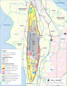
Below the interactive map is a static map depicting the 2032 Noise Contours, the current Noise Remediation Boundary, and current land uses.
Maps are for informational purposes only.